


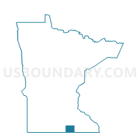
Freeman Twp. Voting District, Freeborn County, Minnesota
About
Outline

Summary
| Unique Area Identifier | 601977 |
| Name | Freeman Twp. Voting District |
| County | Freeborn County |
| State | Minnesota |
| Area (square miles) | 35.81 |
| Land Area (square miles) | 35.75 |
| Water Area (square miles) | 0.06 |
| % of Land Area | 99.84 |
| % of Water Area | 0.16 |
| Latitude of the Internal Point | 43.54252840 |
| Longtitude of the Internal Point | -93.34858220 |
Maps

Graphs
Select a template below for downloading or customizing gragh for Freeman Twp. Voting District, Freeborn County, Minnesota


Neighbors
Neighoring Voting District (by Name) Neighboring Voting District on the Map
- Albert Lea Twp. P-1, Freeborn County, MN
- Glenville Voting District, Freeborn County, MN
- HARTLAND TWP Voting District, Worth County, IA
- Hayward Twp. Voting District, Freeborn County, MN
- Nunda Twp. Voting District, Freeborn County, MN
- Pickerel Lake Twp. Voting District, Freeborn County, MN
- Shell Rock Twp. Voting District, Freeborn County, MN
- SILVER LAKE TWP Voting District, Worth County, IA
Top 10 Neighboring County Subdivision (by Population) Neighboring County Subdivision on the Map
- Pickerel Lake township, Freeborn County, MN (673)
- Albert Lea township, Freeborn County, MN (653)
- Glenville city, Freeborn County, MN (643)
- Freeman township, Freeborn County, MN (496)
- Shell Rock township, Freeborn County, MN (427)
- Hayward township, Freeborn County, MN (381)
- Nunda township, Freeborn County, MN (321)
- Hartland township, Worth County, IA (262)
- Silver Lake township, Worth County, IA (211)
Top 10 Neighboring Place (by Population) Neighboring Place on the Map
Top 10 Neighboring Unified School District (by Population) Neighboring Unified School District on the Map
- Albert Lea Public School District, MN (23,431)
- Lake Mills Community School District, IA (3,888)
- Northwood-Kensett Community School District, IA (3,375)
- Glenville-Emmons School District, MN (2,587)
Top 10 Neighboring State Legislative District Lower Chamber (by Population) Neighboring State Legislative District Lower Chamber on the Map
Top 10 Neighboring State Legislative District Upper Chamber (by Population) Neighboring State Legislative District Upper Chamber on the Map
Top 10 Neighboring 111th Congressional District (by Population) Neighboring 111th Congressional District on the Map
Top 10 Neighboring Census Tract (by Population) Neighboring Census Tract on the Map
- Census Tract 1803, Freeborn County, MN (3,421)
- Census Tract 1807, Freeborn County, MN (2,596)
- Census Tract 1810, Freeborn County, MN (2,362)
- Census Tract 6902, Worth County, IA (2,317)